![]()
![]()
March 2004 Feature
|
March 2004 Feature |
|
|
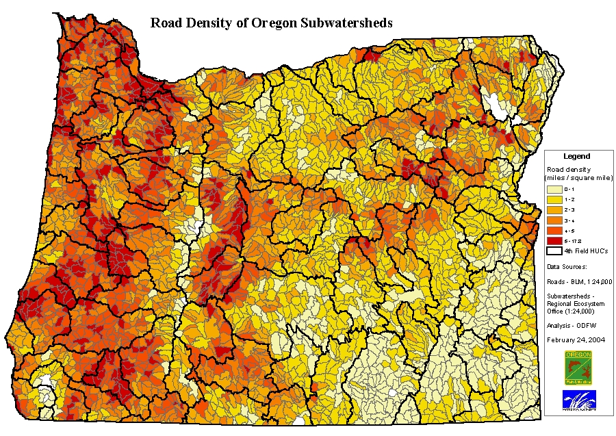
Road Density Analysis
--by Jon Bowers Understanding road density and location can help to gage the impact of roads on natural watershed processes. NOAA Fisheries has defined road densities of less than 2 miles / square mile with no valley bottom roads as "properly functioning". Densities between 2 and 3 miles / square mile with some valley bottom roads are designated as "at risk" and densities over 3 miles / square mile with many valley bottom roads are considered "not properly functioning". (http://www.nwr.noaa.gov/1habcon/habweb/habguide/matrix_1996.pdf) The analysis presented here was intended solely to determine approximate road densities. No attempt has been made to consider the degree to which roads exist within valley bottoms and whether roads restrict stream meanders or affect riparian function within these watersheds. These specific impacts as well as road condition and other factors would need to be evaluated to develop a more comprehensive understanding of the impacts of roads on watershed processes. BLM ground transportation data were projected into the Oregon State Lambert projection then reselected for known roads (rt_type = "RD"). The 9 separate district datasets were then appended into a single statewide roads layer. The watersheds data were projected to the Oregon State Lambert projection and then clipped to the state boundary using the 1:24,000 scale BLM county dataset. This resulted in a dataset that contains some incomplete 6th field watersheds, in particular in areas along the border with other states. However, the dataset is limited to the area where the road data exist, thus enabling a consistent density calculation for both complete and incomplete 6th field watershed layer polygons. The roads layer was then intersected with the clipped 6th field watershed layer in order to assign the watershed attributes to the roads dataset. The total length of roads in miles, within each source watershed layer polygon, was then summarized. The total square miles of each watershed layer polygon was also determined. A calculation was run, dividing the total length of roads in miles by the total watershed layer polygon area in square miles to determine the density value for each watershed layer polygon. The results were then mapped in ArcMap using a manual classification. Breaks were set at the values of 1,2,3,4, 5 and then the max value of 17.8 miles / square mile. Zero values were excluded from the classification and consequently are shaded white.
Data Sources roads BLM Ground Transportation Roads and Trails, 1:24,000 scale (http://www.or.blm.gov/gis/resources/dataset.asp?cid=39) watersheds REO 6th field, 1:24,000 scale watersheds(http://www.reo.gov/gis/data/gisdata/index.htm) References NOAA Fisheries (National Marine Fisheries Service). 1996a. Making Endangered Species Act determinations of effect for individual and grouped actions at the watershed scale. Habitat Conservation Program, Portland, Oregon. September 4, 1996. |
|
|